Sfoglia categorie
Esplora
Fiverr Pro
Italiano
$
USD

Level 1
GIS Specialist
Competenze
Consulta i miei servizi
Assistant Manger GIS
PropMax.ai • Full time
Oct 2021 - Present • 4 yrs 9 mos
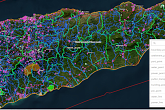
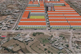
➢Specializing in GIS data management, proficiently managing extensive datasets including POIs, lines, and polygons utilizing PostgreSQL and GeoServer. Spatial data visualization, leveraging diverse OGC layers to craft captivating visualizations on web interfaces ➢Have expertise in creating spatial data infrastructure (SDI) by leveraging tools like open layers, QGIS, PostgreSQL, GeoServer, LeafletJS, and Mapbox APIs to organize and manage datasets effectively. ➢I am working on developing an innovative online property verification system for Pakistan, enabling users to verify their properties easily by clicking on the corresponding polygon or plot. (JS, PHP, Leaflet, Mapbox) ➢I am involved in a feasibility project where we provide location-based services to clients. For example, I determine suitable locations for new businesses by analyzing proximity to residential areas, airports, hospitals, etc., through buffer creation and analysis. ➢I conducted 3D visualization using ArcGIS Pro and CityEngine to support decision-making in the real estate sector. ➢Performed hydrological analysis, land use/land cover classification, static mapping, and online mapping using ArcGIS and ArcGIS Online to support future development initiatives. ➢Collaborated with the Better Cotton Initiative team, employing GIS technologies such as Google Earth Engine, ArcGIS, Power BI, pgsql, Geoserver, JavaScript, and PHP for mapping and analyzing the sustainable growth of cotton cultivation in Pakistan. ➢Engaged in creating 3D visualizations of properties using cesium, enhancing the user experience and enabling immersive exploration. ➢I specialize in optimizing routing applications by utilizing spatial queries to dynamically generate efficient routes on road networks, ensuring quick and accurate results.
Senior 3D WebGIS Specialist
City Pulse (Pvt) Ltd • Part time
Sep 2024 - Jul 2025 • 10 mos
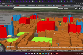
➢Leading the development of Pakistan’s first large-scale 3D Geospatial Digital Twin City for RUDA (Ravi Urban Development Authority) enabling data-driven urban planning and smart infrastructure management. ➢Developed and optimized 3D Digital Twin environments using CesiumJS, GeoServer, PostgreSQL, and open-source geospatial technologies. ➢Rendered and extruded millions of textured polygons with performance optimization techniques for smooth real-time 3D visualization of large urban environments ➢Integrated multi-source geospatial data GIS layers, CAD drawings, master plans, topography, satellite imagery, and IoT-ready datasets into an intelligent urban simulation model. ➢Designed and implemented real-time vehicle movement animations along polyline-based road networks to simulate realistic urban mobility. ➢Managed complex multi-layer rendering pipelines, ensuring smooth performance and accurate 3D representation of terrain, buildings, and infrastructure. ➢Enhanced 3D application UI/UX and data streaming, enabling immersive exploration and analytical capabilities within the digital twin platform. ➢Collaborated with architects and planners to embed geospatial intelligence into 3D WebGIS environments, bridging design and data for dynamic decision support. ➢Developed public-access 3D visualization tools, empowering citizens and stakeholders to explore future urban growth interactively.
RS and GIS Consultant
Resilience Gateway (Pvt) Ltd • Part time
Oct 2023 - Nov 2024 • 1 yr 1 mo
➢Developed a real-time cotton analysis application using Google Earth Engine and Sentinel-2A data for monitoring crop productivity and optimizing resource allocation. ➢Processed and analyzed multi-temporal satellite imagery for data-driven agricultural and urban planning insights. ➢Built the GIS-based PIMS (Property Inspection Management System) to support land information systems, feasibility studies, and environmental assessments. ➢Designed and deployed geospatial web applications using PostgreSQL/PgAdmin, GeoServer, JavaScript, and Laravel for efficient spatial data management and visualization.
| (8) | ||
| (1) | ||
| (0) | ||
| (1) | ||
| (0) |

fightalex
Cliente abituale

Stati Uniti

mdicko45

Puerto Rico
It took a few iterations to get to the final product to the level of expected quality, but in the end the work was well done.
alexlivshiz

Israele
Amazing 3d web developer it work fast and quality is good
Risposta del venditore
fightalex
Cliente abituale
Stati Uniti
Did a great job and explained what we did in detail
fightalex
Cliente abituale
Stati Uniti
The map was what i needed but not WHEN I needed. This is the second job in a row that was very very late. Do not trust what he says in chat.