I will digitize US zoning maps, create zoning reports property controls for real estate

A
adnansalik12
A
adnansalik12
Adnan Salik
5,0
5,0
Alcune informazioni sono riportate in lingua inglese.

Informazioni su questo servizio

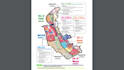
Accurate & Professional USA Zoning Map Digitization for Real Estate Projects


Are you a real estate investor, developer, or planner who needs accurate zoning map digitization and land use data across the United States?

I'm Adnan, a GIS Expert with over 8 years of experience in zoning, land use controls, parcel mapping, and urban planning projects. I specialize in helping clients visualize zoning boundaries, understand property restrictions, and create geospatial maps that support decision-making.

What I Offer:

  • USA zoning map digitization (city, county, state-level)
  • Land use & zoning code integration (e.g. R1, C2, RM, A1)
  • Custom layers: setbacks, overlays, cannabis zones, flood zones
  • Parcel-level zoning reports
  • Controls: rear/front/side yard setbacks, FAR, height limits, etc.
  • High-resolution GIS/Map visualizations
  • GeoJSON, SHP, KML, or PDF delivery

Ideal for:

  • Real estate due diligence
  • Property research
  • City planning projects
  • Investment analysis
  • Zoning overlays & use restriction checks


Tools: ArcGIS, QGIS, Google Earth, Mapbox, Illustrator


Message me before placing your order to discuss location and zoning source.

Scopri di più su Adnan Salik

Adnan Salik

Multifaceted GIS Developer, Remote Sensing, Spatial Data Scientist

5,0(189)
  • DaPakistan
  • Membro damag 2019
  • Tempo di risposta medio1 ora
  • Ultima consegna1 anno
  • Lingue

    Inglese, Francese, Spagnolo, Tedesco
Hey, I'm Adnan, I'm very experienced Graphic Designer, GIS Analyst, Cartographer. A Digital Cartoonist and Caricature Artist From Pakistan at your home screens to turn your imaginations into Life of fun & Colors.. I can help in: Graphic Designing:- Cartoon caricature ,Cartoon portrait, Photo Editing, Illustrations, Vector Tracing, Children book illustrations, Can Provide all kind of Graphic designing work. GIS or Spatial Analysis:- Interactive mapping, vector map, spatial analysis,Web Mapping,3D analysis, modeling , GIS automation,Spatial Databases, GIS Softwares (ArcGIS, QGIS,ERDAS,ENVI)

Il mio portfolio

Recensioni

1 recensioni per questo servizio
5,0

(1)
(0)
(0)
(0)
(0)
Valutazione dettagliata
  • Livello di comunicazione del venditore
    5
  • Qualità della consegna
    5
  • Valore della consegna
    5
Ordina per
Più rilevante
  • G
    image-docs

    gregxasun

    US

    Stati Uniti

    5

    Adnan is top notch! Extremely responsive which is why I decided to work with him in the first place and he did the top exactly how I needed.

    100 USD-200 USD

    Prezzo

    7 giorni

    Tempo

    Utile?
    No