d
danishmurad177

Danish Murad

@danishmurad177
4,8(4)

Professional GIS Analysis, Mapping, and Data Visualization Services

Pakistan
Inglese, Urdu
Alcune informazioni sono riportate in lingua inglese.
Chi sono
I am a GIS and Remote Sensing Specialist with 6+ years of experience delivering accurate, decision-driven geospatial solutions. My expertise includes spatial analysis, thematic and cartographic mapping, remote sensing, data visualization, and geodatabase management using ArcGIS, QGIS, Google Earth Engine, and Web GIS platforms. I transform complex geographic data into clear, actionable insights through high-quality maps, reports, and interactive solutions. I am committed to precision, timely delivery, and clear communication, ensuring every project provides reliable results.... Continua a leggere

Competenze

d
danishmurad177
Danish Murad
offline • 
Tempo di risposta medio: 1 ora

Consulta i miei servizi

Geographic Information Systems (GIS)
I will create gis maps, georeference maps, and do spatial analysis services
4,5(2)
Geographic Information Systems (GIS)
I will do map georeferencing and digitization in qgis arcgis and google earth engine
5,0(2)

Portfolio

Esperienza lavorativa

Glacier segmentation

EvK2CNR • Full time

Dec 2023 - Jun 20246 mos

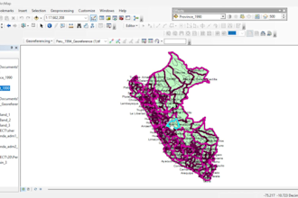
This project was completed for EvK2CNR and involved georeferencing and digitizing scanned maps for GIS use. The maps were aligned with real-world coordinates using accurate ground control points to ensure spatial precision. After georeferencing, key features were digitized into clean vector layers with proper attributes and topology. The final deliverables included georeferenced raster files and GIS-ready vector data, compatible with ArcGIS and QGIS, supporting EvK2CNR’s environmental and geographic research work.

4 Recensioni
4,8

(3)
(1)
(0)
(0)
(0)
Valutazione dettagliata
  • Livello di comunicazione del venditore
    4,8
  • Qualità della consegna
    4,8
  • Valore della consegna
    4,8
1-4 di 4 recensioni
Ordina per
Più rilevante
    G

    gov_tuzi_2026

    ME

    Montenegro

    5

    Amazing collaboration!

    200 USD-400 USD

    $

    8 giorni

    Tempo

    gig

    Geographic Information Systems (GIS)

    Utile?
    No
    T

    tokuna1982

    UG

    Uganda

    4

    The work was well executed although it took alittle longer than the designated time.

    Fino a 50 USD

    $

    3 giorni

    Tempo

    gig

    Geographic Information Systems (GIS)

    Utile?
    No
    M

    mamtamehar

    IN

    India

    5

    Excellent work—professional, responsive, and has paid attention to all the details.

    Fino a 50 USD

    $

    8 giorni

    Tempo

    gig

    Geographic Information Systems (GIS)

    Utile?
    No
    J

    joaco_ec

    EC

    Ecuador

    5

    It was great working with Danish! He was super responsive to feedback and the tweaks I requested along the way. He handled feedback very well and resolved all the issues that came up. Highly recommended! He was also communicative and asked for clarification when needed, which saved me a lot of time.

    Fino a 50 USD

    $

    3 settimane

    Tempo

    gig

    Geographic Information Systems (GIS)

    Utile?
    No