Sfoglia categorie
Esplora
Fiverr Pro
Italiano
$
USD

Level 2


Traduzione automatica.
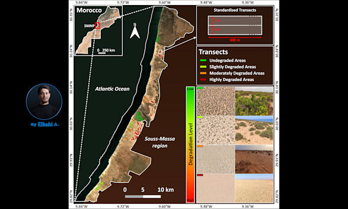
Progetto mappe personalizzate di alta qualità utilizzando dati raster, vettoriali e tabellari.
Tipi di mappe che creo: mappe di riferimento e mappe tematiche - mappa coropletica, mappa con simboli proporzionali, mappa con simboli graduati, mappa di densità di punti, mappa termica, mappa web interattiva (opuscolo), mappa infografica, mappa di densità, mappa fisica, mappa politica, mappa isocrona (aree raggiungibili entro un tempo o una distanza), mappa del tempo di percorrenza, mappa delle reti stradali/ferroviarie, mappa catastale, mappa climatica, mappa geologica, mappa della copertura del suolo, mappa delle isolinee, mappa dei contorni, mappa dei modelli digitali di elevazione, mappa satellitare (immagini Landsat, Sentinel-2, MODIS), cartogramma.
Le analisi che svolgo includono: digitalizzazione (digitalizzazione di dati geografici), delimitazione di poligoni, analisi di prossimità (analisi buffer), interpolazione spaziale, analisi di correlazione, analisi temporale o rilevamento dei cambiamenti, analisi di idoneità (selezione del sito), analisi del terreno, conversione di formati e georeferenziazione (georeferenziazione di mappe come mappe storiche, mappe scansionate o mappe non geospaziali).
I formati su cui lavoro includono: GeoTIFF, Shapefile, GeoJSON, KML / KMZ, ESRI ASCII, JPEG, PNG, CSV, Microsoft Excel e molti altri.
Per favore, discutiamo del progetto prima di effettuare un ordine.
Data Made Visual, Insights Made Clear
Level 2
Lingue
Traduzione automatica.
| (12) | ||
| (0) | ||
| (0) | ||
| (0) | ||
| (0) |
whitmars

Stati Uniti
Super easy to work with and professional. The process was easy, and he was understanding when I requested changes; he delivered wonderfully. I plan to come back at a later date with another project.
100 USD-200 USD
Prezzo
4 settimane
Tempo

Risposta del venditore

rushextreme
Cliente abituale

Lettonia
The order was completed perfectly, and very fast. Went above and beyond, the best on Fiver!
Fino a 50 USD
Prezzo
1 giorno
Tempo
Risposta del venditore

opt4text
Cliente abituale
Stati Uniti
Elbahi A. was great, quality delivery, excellent communication, and went the extra mile with additional research and ideas. When a minor snag accrued after delivery, he adjusted immediately without hesitation. Highly recommend and will definitely use again!
Fino a 50 USD
Prezzo
2 giorni
Tempo
Risposta del venditore
coreyf08
Stati Uniti
Awesome to work with and was very flexible with the design and made all of my revision requests. Delivered ahead of schedule. Will definitely use again for any geospatial mapping needs!
Fino a 50 USD
Prezzo
2 giorni
Tempo
Risposta del venditore
rushextreme
Cliente abituale
Lettonia
Very fast and precisely what I needed.
Fino a 50 USD
Prezzo
1 giorno
Tempo
Risposta del venditore
| (12) | ||
| (0) | ||
| (0) | ||
| (0) | ||
| (0) |
whitmars
Stati Uniti
Super easy to work with and professional. The process was easy, and he was understanding when I requested changes; he delivered wonderfully. I plan to come back at a later date with another project.
100 USD-200 USD
Prezzo
4 settimane
Tempo
Risposta del venditore
rushextreme
Cliente abituale
Lettonia
The order was completed perfectly, and very fast. Went above and beyond, the best on Fiver!
Fino a 50 USD
Prezzo
1 giorno
Tempo
Risposta del venditore
opt4text
Cliente abituale
Stati Uniti
Elbahi A. was great, quality delivery, excellent communication, and went the extra mile with additional research and ideas. When a minor snag accrued after delivery, he adjusted immediately without hesitation. Highly recommend and will definitely use again!
Fino a 50 USD
Prezzo
2 giorni
Tempo
Risposta del venditore
coreyf08
Stati Uniti
Awesome to work with and was very flexible with the design and made all of my revision requests. Delivered ahead of schedule. Will definitely use again for any geospatial mapping needs!
Fino a 50 USD
Prezzo
2 giorni
Tempo
Risposta del venditore
rushextreme
Cliente abituale
Lettonia
Very fast and precisely what I needed.
Fino a 50 USD
Prezzo
1 giorno
Tempo
Risposta del venditore