Sfoglia categorie
Esplora
Fiverr Pro
Italiano
$
USD

Traduzione automatica.
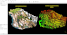
In relazione a dati delle rilevazioni con drone, saranno forniti i seguenti servizi:
- Pianificazione delle rilevazioni (griglie di rilevamento) usando UAV con marcatura GCP.
- Elaborazione dei dati drone con o senza Ground Control Points.
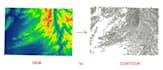
- Generazione di ortomosaici, DEM, DTM e DSM
- Generazione di contorni
- Point Cloud
- Digitalizzazione completa (file shapefile GIS o disegno CAD)
- Sistemi di elaborazione ad alte prestazioni in grado di gestire centinaia di GB di dati.
Discuti il progetto prima di effettuare l'ordine.
Fyaz
Lingue
Traduzione automatica.


