Sembra che questo servizio sia in sospeso

I will develop interactive leaflet, mapbox web map application

H
hamzakhanhere
H
hamzakhanhere
Zohaibhassan
Alcune informazioni sono riportate in lingua inglese.

Informazioni su questo servizio

Having a degree in geo-informatics, I can work both as GIS analyst and GIS developer. I'll be proving you the solutions of your problems using different analysis softwares like ArcGIS (ArcMap), ArcGIS Pro, ArcScan, QGIS, and Erdas Imagine.

For 3D modelling I'll be using photogrammetric techniques with the help of softwares like Pix4D, GIMP and Meshroom.

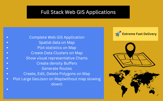
I'll create gis mapping applications for you using mapping libraries, html, css , javascript and python.

Below are the major services, I'll be providing:

  • Spatial Analysis
  • Web applications using javascript & python languages
  • Leaflet
  • DSM, DTM and DEM
  • Coordinate System
  • GIS Digitization
  • Cartographic Maps
  • Suitability Analysis Mapping
  • Point, Line, Polygon, Raster to vector and vice versa
  • Shapefile, Feature Class, Geodatabase, kml etc
  • Web embedding of maps and Geocoding
  • OSRM
  • ARcGIS Software Development Kits and API
  • MaqQuest
  • Google Map APIs
  • Topology
  • Parcel Fabric Editing
  • Road or Land Use maps
  • Google Earth Mapping
  • Merge/Buffer
  • Site suitability
  • Satellite image processing mapping
  • Georeferencing, address Geocoding and reverse Geocoding
  • 3D Modeling, Flood Animation, 3D Path Tracking Animation


Scopri di più su Zohaibhassan

Zohaibhassan
2,8(2)
  • DaPakistan
  • Membro daapr 2023
  • Ultima consegna2 anni
  • Lingue

    Inglese
.