I will design hiking trail maps, trekking maps, and recreation maps

K
keljude
K
keljude
Kelvin. D
Alcune informazioni sono riportate in lingua inglese.

Informazioni su questo servizio

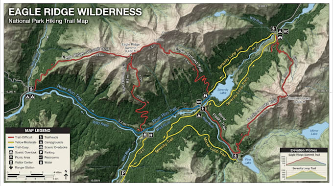
Planning an outdoor adventure, managing a trail network, or promoting a recreation destination? I create professionally designed hiking maps that combine visual appeal, accuracy, and functionality for parks, campgrounds, tourism projects, outdoor events, and trail systems.

I craft unique, visually compelling hiking maps that blend accurate trail information, intuitive wayfinding, and creative design to deliver an exceptional outdoor navigation experience.

What You'll Receive

  • Custom hiking trail maps
  • Trailhead and waypoint markers
  • Elevation profiles and terrain representation
  • Distance and difficulty indicators
  • Campsites, viewpoints, and points of interest
  • Custom icons and branding
  • Print Ready and digital formats
  • High resolution PDF, PNG, JPG, or source files

Why Choose Me?

  • Professional map design expertise
  • Clean, user friendly layouts
  • Accurate trail visualization
  • Quality illustrations and cartography
  • Fast communication and reliable delivery
  • Fully customized designs tailored to your project

I am committed to creating hiking maps that not only guide visitors but also enhance their outdoor experience through engaging and visually compelling design.

Preferenza per lo stile di consegna

Informa il freelance di eventuali preferenze o preoccupazioni relative all'uso di strumenti di IA nel completamento e/o nella consegna dell'ordine.

Scopri di più su Kelvin. D

Kelvin. D

Creating Smarter Maps for Better Places

  • DaRegno Unito
  • Membro dagiu 2026
  • Lingue

    Inglese, Tedesco
Every successful development begins with a clear vision, and my role is to transform that vision into compelling visual maps that communicate ideas with confidence and clarity. I design detailed master plans and development maps for waterfront communities, marina districts, harbor developments, ports, residential subdivisions, mixed use projects, and tourism destinations. By combining planning principles with high-end visual presentation, I produce maps that help developers, investors, architects, and stakeholders better understand the scale, functionality, and character of a project.