Sfoglia categorie
Esplora
Fiverr Pro
Italiano
$
USD

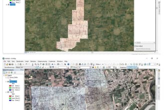
I will do all sort of Remote sensing and GIS Mapping using Arc GIS
Competenze
Consulta i miei servizi

GIS QC Expert
R2V Private Limited • Full time
Aug 2024 - Present • 1 yr 11 mos
I am currently working with R2V as a GIS QC Expert and Research Assistant, where I've worked on various projects including GIS layout development for Defence Housing Authorities (DHA) in Pakistan, focusing on data development, quality control and data publication into web maps. Previously, I worked as a Team Lead on the Punjab Urban Land Systems Enhancement (PULSE) project for Rawalpindi Division, ensuring data accuracy and integrity of spatial datasets through robust validation processes and advanced GIS technologies. Additionally, I've worked on the GIS based land record computerisation of Balochistan project for Board of Revenue, Balochistan, where I was responsible for tasks such as spatial data collection, editing, digitization, feature extraction, and land record management, utilizing geospatial data conversions, analysis, mapping and visualisation.
GIS Analyst
Tech-GIS • Full time
Jan 2023 - Aug 2024 • 1 yr 7 mos
Project: Cadastral mapping of state lands, Survey of Pakistan. Divisions: Lahore, Peshawar, DG Khan and Bahawalpur. Responsibilities: The work consisted of constructing comprehensive geospatial datasets developing accurate geospatial datasets for cadastral mapping across multiple districts. I was responsible for assembling and integrating Massavi sheets into continuous raster layers, registering spatial data to correct coordinate systems, and converting paper-based records into digital vector formats by delineating parcels and linear features at the Mouza level. I performed topology validation and error correction, resolving gaps and overlaps, and conducted edge matching of vector layers to ensure seamless locality-wise data integration. Additionally, I carried out attribute analysis for comprehensive data accuracy and prepared final reports documenting both raster and vector datasets, ensuring high-quality outputs suitable for cadastral and land management purposes.
GIS Associate
Greenage Services • Full time
Feb 2021 - Feb 2024 • 3 yrs
Project: Land Record Information & Cadastral Mapping of State Lands, Pakistan Divisions: Sahiwal, Sargodha, Faisalabad, and Multan Description: The project involved developing geospatial datasets from raw images and mussavies and converting them into accurate digital maps. I worked on developing raster maps through clipping, Stitching, mosaicking, and georeferencing of scanned data, as well as coverting into Digital Vector data through digitizing Mouza boundaries to create detailed cadastral layers. This included generating an initial grid index aligned to ground scale and entering square and Khasra numbers for precise land parcel identification. I also extracted the spatial extent of state lands across the districts of Punjab, analyzed land use patterns, and assessed the road network connectivity to support planning and resource management. The work involved transforming paper maps and scanned imagery into highly accurate vector datasets, ensuring usability for cadastral and land record management purposes.
| (1) | ||
| (0) | ||
| (0) | ||
| (0) | ||
| (0) |
tiro210

Germania
Noorzadi was very helpfull und delivered the outcome on time!