Sfoglia categorie
Esplora
Fiverr Pro
Italiano
$
USD

Develop Professional Agricultural GIS Maps and Spatial Analysis for Precision Farming
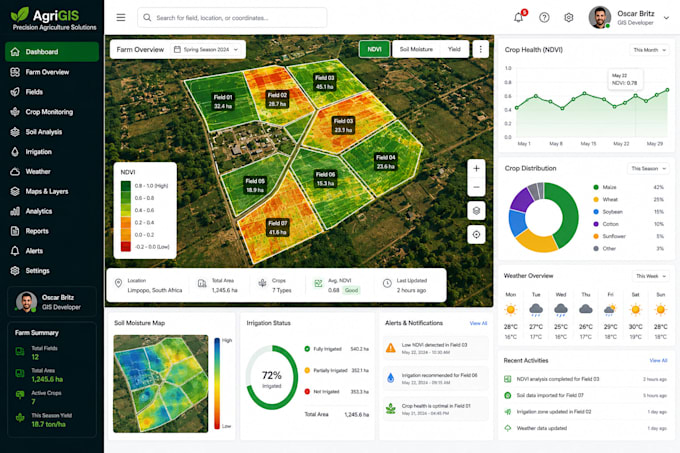
Are you looking for accurate Agricultural GIS solutions to improve farm management, crop monitoring, or land analysis? You're in the right place!
I provide professional GIS services for farmers, agribusinesses, agricultural consultants, researchers, NGOs, and government organizations. Using modern GIS technologies and spatial analysis, I deliver high-quality maps and geospatial solutions that support better planning and informed decision-making.
Services I Offer
Please contact me before placing an order so we can discuss your project requirements, available data, timeline, and the most suitable package.
Oscar Dev
Lingue
What agricultural GIS services do you provide?
I provide a wide range of Agricultural GIS services, including farm boundary mapping, precision agriculture, land use and land cover mapping, soil analysis, irrigation planning, crop health monitoring, NDVI analysis, satellite imagery processing, land suitability analysis, and interactive Web GIS
What software and technologies do you use?
I work with industry-standard GIS technologies such as ArcGIS Pro, QGIS, Leaflet, OpenLayers, Mapbox, GeoServer, PostgreSQL/PostGIS, and Python for spatial analysis and Web GIS development.
What data formats do you accept?
I can work with Shapefiles (SHP), GeoJSON, KML/KMZ, CSV, Excel files, GPS coordinates, satellite imagery, GeoTIFFs, and other common geospatial data formats.
Can you analyze satellite imagery for crop monitoring?
Yes. I can process satellite imagery to perform vegetation analysis, NDVI mapping, land cover classification, crop health assessment, and other agricultural spatial analyses.
Can you create interactive Web GIS applications for agriculture?
Yes. I can develop custom Web GIS applications with interactive maps, dashboards, filters, and spatial visualization to help manage agricultural data efficiently.
Will I receive the source files?
Yes. All relevant GIS data, map files, and source files included in your selected package will be delivered upon project completion.
Can you help with irrigation and land suitability analysis?
Absolutely. I can perform spatial analysis for irrigation planning, land suitability assessment, soil mapping, and other location-based agricultural studies.
Can you customize the project according to my requirements?
Yes. Every farm, agricultural business, and research project is different. I provide customized GIS solutions based on your objectives, available data, and project scope.
How long will the project take?
Delivery time depends on the complexity of the project, data availability, and requested features. I will provide an estimated timeline after reviewing your requirements.
Should I contact you before placing an order?
Yes. Please contact me before placing an order so we can discuss your project requirements, available datasets, expected deliverables, and select the most suitable package.