Sfoglia categorie
Esplora
Fiverr Pro
Italiano
$
USD

Traduzione automatica.
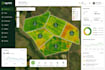
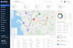
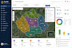
Sviluppa un'applicazione web di mapping GIS personalizzata per la tua attività
Stai cercando uno sviluppatore GIS professionista per creare un'applicazione di mapping web potente e interattiva su misura per le tue esigenze? Sei nel posto giusto!
Sono specializzato nella progettazione e nello sviluppo di applicazioni GIS personalizzate che trasformano i dati spaziali in mappe e dashboard intuitive e interattive. Che tu sia nel settore immobiliare, logistica, gestione ambientale, pianificazione urbana, agricoltura o gestione patrimoniale, posso creare una soluzione che ti aiuti a visualizzare, analizzare e gestire i dati basati sulla posizione in modo efficiente.
Cosa Offro
Ti prego di inviarmi un DM prima di effettuare l'ordine!
Ricorda che è contrario alle politiche di Fiverr per i freelance includere temi, modelli o qualsiasi altro elemento che violi i diritti di terzi o le leggi applicabili nell'opera consegnata. Per saperne di più, consulta Guida alla creazione digitale responsabile.
Oscar Dev
Lingue
Traduzione automatica.
Traduzione automatica.
Di quali informazioni hai bisogno per iniziare?
Per favore, fornisci una descrizione dettagliata del tuo progetto, i tuoi dati GIS (se disponibili), le funzionalità di mappa preferite, i requisiti di design e eventuali esempi di riferimento. Se non hai ancora dati GIS, posso aiutarti a determinare il miglior approccio.
Quali formati di dati GIS supporti?
Lavoro con una vasta gamma di formati di dati geospaziali, tra cui Shapefile (SHP), GeoJSON, KML/KMZ, GPX, CSV, GeoPackage, PostGIS e altri dataset GIS comuni.
Quali tecnologie di mappatura utilizzi?
A seconda delle esigenze del tuo progetto, sviluppo applicazioni usando Leaflet, Mapbox GL JS, OpenLayers, API ArcGIS, PostGIS, GeoServer, React, JavaScript, Node.js e Python.
Puoi creare un'app GIS per il mio settore?
Sì. Sviluppo soluzioni GIS personalizzate per immobili, logistica, trasporti, gestione ambientale, agricoltura, utility, enti pubblici, pianificazione urbana, costruzioni, turismo e molti altri settori.
La mia mappa web funzionerà sui dispositivi mobili?
Assolutamente sì. Ogni applicazione web GIS è progettata per essere responsive e funzionare senza problemi su desktop, tablet e dispositivi mobili.
È possibile integrare API o database esterni?
Sì. Posso integrare API REST, servizi Google Maps, PostGIS, PostgreSQL, GeoServer e altri servizi di terze parti in base alle esigenze del progetto.
Fornisci il codice sorgente?
Sì. Riceverai codice sorgente pulito e ben documentato come parte del progetto completato, salvo diverso accordo prima dell'inizio dello sviluppo.


