Sfoglia categorie
Italiano
$
USD
Connettiti alla tua IA

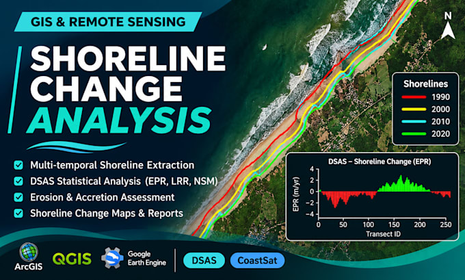
Do you need to quantify shoreline changes and assess coastal erosion and accretion? I provide scientific shoreline change analysis using GIS, remote sensing, CoastSat, and the Digital Shoreline Analysis System (DSAS).
My services include:
Using ArcGIS, QGIS, CoastSat, DSAS, and suitable Landsat or Sentinel imagery, I help assess spatial and temporal patterns of coastal change.
Deliverables: High-resolution maps, statistical results, GIS files, and scientific interpretation, depending on your selected package.
Please share your study area, target dates, available data, and required outputs before ordering. For extensive coastlines or complex projects, contact me for a custom offer.
I provide professional GIS and Remote Sensing services
Lingue
What information do you need to start the analysis?
Please provide your study area, target years, and required outputs. You can share a boundary shapefile, KML, coordinates, or existing shoreline data. If you do not have satellite imagery, I can assess the availability of suitable public data.
Do you provide DSAS-based shoreline change analysis?
Yes, I provide shoreline change analysis using DSAS, including EPR, LRR, NSM, and SCE metrics where appropriate, depending on the suitability of the available shoreline data.
Can you assess coastal erosion and accretion?
es, I compare shoreline positions across different dates to identify shoreline movement and assess erosion and accretion patterns using GIS and remote sensing.
What deliverables will I receive?
Depending on your selected package, deliverables may include high-resolution maps, shoreline change statistics, tables, charts, GIS datasets, and a concise scientific results summary.
Can you handle large coastal areas or additional requirements?
Yes, larger study areas, additional shoreline dates, extensive satellite image processing, and detailed scientific reporting can be discussed through a custom offer. Please contact me before ordering.
