Sfoglia categorie
Esplora
Fiverr Pro
Italiano
$
USD
Level 2


Traduzione automatica.
Ciao, sono Rashid
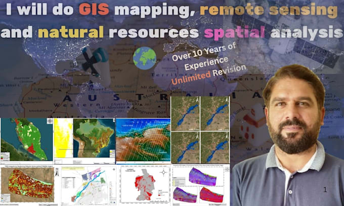
Sono uno specialista in GIS & Remote Sensing con oltre 10 anni di esperienza in analisi geospaziali, mappatura delle risorse naturali, valutazione ambientale, rischi geologici, gestione delle emergenze e progetti infrastrutturali. Offro soluzioni professionali e di alta qualità, personalizzate in base alle tue esigenze, utilizzando strumenti come ArcGIS, QGIS, GEE, ERDAS, Global Mapper e AutoCAD.
Servizi che offro:
Offro soluzioni professionali per garantirti la soddisfazione. Sono disponibile 24/7 e personalizzate in base al tuo budget. Contattami oggi per servizi con precisione superiore e risultati tempestivi.
Earth Explorer Geologist!
Level 2
Lingue
Traduzione automatica.
Traduzione automatica.
Quali software/strumenti GIS utilizzi?
FME, ArcGIS Suite, ArcGIS Enterprise, QGIS, Python
Potete aiutarmi a trovare fonti di dati per il mio progetto?
Sì, ti aiuterò a trovare dati open e a preparare i dataset necessari per il tuo progetto.
| (9) | ||
| (1) | ||
| (0) | ||
| (1) | ||
| (0) |
oliverj09

Regno Unito
Excellent experience! Highly professional, knowledgeable, and detail-oriented. The work was accurate, well-presented, and delivered on time. Great communication throughout. I highly recommend this geoscientist and would gladly work with them again.
Fino a 50 USD
$
1 giorno
Tempo

Risposta del venditore
judylynn44

Stati Uniti
Very pleased that the assignment was completed prior to the due date.
100 USD-200 USD
$
4 giorni
Tempo
Risposta del venditore
crepin_96

Germania
Professionalism
100 USD-200 USD
$
5 giorni
Tempo
chrisfagan13
Cliente abituale
Stati Uniti
Rashid Menhas Geoscientist did a wonderful job with this project. I would strongly recommend his work. Thank you!
200 USD-400 USD
$
4 giorni
Tempo
laurent20
Cliente abituale

Ruanda
Impressive understanding of geology, minerals, and GIS techniques. Great experience and highly recommended
50 USD-100 USD
$
10 giorni
Tempo
| (9) | ||
| (1) | ||
| (0) | ||
| (1) | ||
| (0) |
oliverj09
Regno Unito
Excellent experience! Highly professional, knowledgeable, and detail-oriented. The work was accurate, well-presented, and delivered on time. Great communication throughout. I highly recommend this geoscientist and would gladly work with them again.
Fino a 50 USD
$
1 giorno
Tempo
Risposta del venditore
judylynn44
Stati Uniti
Very pleased that the assignment was completed prior to the due date.
100 USD-200 USD
$
4 giorni
Tempo
Risposta del venditore
crepin_96
Germania
Professionalism
100 USD-200 USD
$
5 giorni
Tempo
chrisfagan13
Cliente abituale
Stati Uniti
Rashid Menhas Geoscientist did a wonderful job with this project. I would strongly recommend his work. Thank you!
200 USD-400 USD
$
4 giorni
Tempo
laurent20
Cliente abituale
Ruanda
Impressive understanding of geology, minerals, and GIS techniques. Great experience and highly recommended
50 USD-100 USD
$
10 giorni
Tempo