Sfoglia categorie
Esplora
Fiverr Pro
Italiano
$
USD

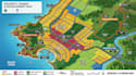
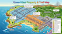
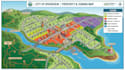
TURN LAND DATA INTO A CLEAR PROPERTY STORY.
A property map should do more than show lines on a screen. I build GIS maps that bring parcel boundaries, zoning, land use, access, and surrounding features into one readable spatial picture helping developers, planners, investors, surveyors, architects, and property researchers understand an area before making decisions.
SPATIAL SCOPE:
DECISION VALUE:
MAPPING LOGIC:
PROJECT EDGE:
BUYER CONFIDENCE:
You receive a map built around the property questions that matternot just a collection of colored layers.
Your supplied data, boundaries, zoning information, or GIS sources can be organized into a coherent property view.
SEND YOUR PROPERTY DATA OR AREA DETAILS AND LETS TURN THE LOCATION INTO ACTIONABLE GIS INFORMATION.
Informa il freelance di eventuali preferenze o preoccupazioni relative all'uso di strumenti di IA nel completamento e/o nella consegna dell'ordine.
Cartographer and GIS mapping specialist
Lingue
Can you guarantee that my parcel boundary is legally accurate?
I can map and visualize the boundary information you provide or obtain from an agreed authoritative source, but a GIS map does not replace a licensed land survey or establish legal ownership. If boundary data is uncertain, I can clearly identify that limitation instead of presenting an assumption as
What happens if my zoning or land use data is incomplete?
I won't quietly fill missing information with guesses. I can identify gaps, organize the available sources, and distinguish supplied, sourced, and unavailable information so you know exactly what the map represents.
Can I use the GIS files for further property analysis?
Yes. Where the required source data and scope allow, I can provide organized GIS layers and editable spatial data, rather than only giving you a flat image. This allows you to continue examining parcels, zoning, land use, and other mapped features.
How do I know the map isn't just visually attractive but spatially useful?
The workflow focuses on layer relationships, coordinates, attributes, boundaries, labels, and geographic context. I structure the map so important property information can be located, compared, and interpreted rather than simply decorating the page.
What if my property information contains confidential project data?
Your project information stays focused on the mapping task. You can provide only the files and details required for the agreed scope, and sensitive information can be excluded from the final map when it isn't necessary for the requested analysis.


