Sfoglia categorie
Esplora
Fiverr Pro
Italiano
$
USD
Level 1


Traduzione automatica.
Sono un Ingegnere Geospaziale (MSc) con oltre 15 anni di esperienza nella creazione di Modelli Digitali di Elevazione, mappe di contorno, soluzioni GIS, LiDAR e rilievi. Aiuto ingegneri, consulenti, ricercatori e sviluppatori terrieri a trasformare i dati di elevazione grezzi in modelli di superficie precisi e pronti per le decisioni.
Questo servizio include:
Deliverables principali
Servizi aggiuntivi
Consegno nel formato e nella risoluzione che si adattano al tuo software. Dimmi solo quale programma usi e adatterò i file di conseguenza.
Strumenti che utilizzo: ArcGIS Pro, QGIS, Google Earth, Global Mapper, Pix4D, Metashape, AutoCAD Civil 3D
Affidato da clienti ricorrenti in tutto il mondo.
Scrivimi la tua fonte di dati e l'area del progetto (indirizzo, coordinate o pin di Google Maps), e ti confermerò l'ambito, i deliverables e i tempi prima che tu effettui l'ordine.
GIS Mapping, Drone Surveying, CAD Site Plans, 3D Modeling and Animations
Level 1
Lingue
Traduzione automatica.
Traduzione automatica.
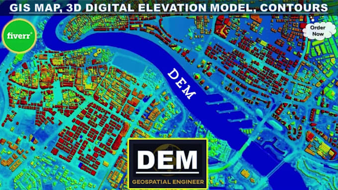
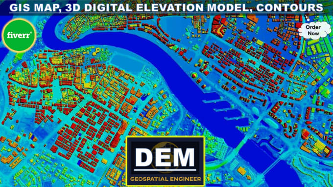
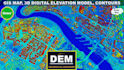
Che cos'è un modello di elevazione digitale (DEM)?
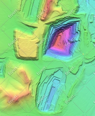
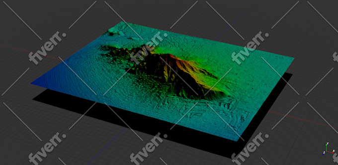
Un modello di elevazione digitale (DEM) è una rappresentazione grafica computerizzata 3D dei dati di elevazione per rappresentare il terreno. DEM è un layer GIS raster con griglie raster della superficie terrestre riferite al datum verticale (Zero Elevation).
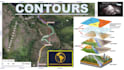
Cosa sono le curve di livello e le mappe topografiche?
In parole povere, le curve di livello segnano punti di uguale elevazione su una mappa. La topografia è lo studio delle caratteristiche geografiche di un paesaggio. Una mappa con linee di contorno su di essa è chiamata mappa topografica. In sostanza, le mappe topografiche rappresentano il paesaggio tridimensionale della Terra all'interno dello spazio 2D di una mappa.
Quali dati sono necessari per creare un DEM e una mappa delle curve di livello?
Per creare un DEM e una mappa dei contorni, in genere ho bisogno di dati di elevazione da fonti quali rilievi topografici del territorio o rilievi del terreno (GNSS, DGPS, stazione totale, scanner laser, LiDAR), immagini stereo fotogrammetriche (immagini satellitari, fotografie aeree), SAR, set di dati radar o fogli topografici.
È possibile personalizzare gli intervalli delle curve di livello e le specifiche della mappa in base alle mie esigenze?
Assolutamente! Capisco che progetti diversi possono avere requisiti unici. Che tu abbia bisogno di intervalli di contorno specifici, estensioni di mappa, sistemi di coordinate o altre specifiche, posso personalizzare i risultati per soddisfare le tue esigenze specifiche.
Quali tipologie di progetti possono beneficiare dei vostri servizi?
I miei servizi sono ideali per un'ampia gamma di progetti, tra cui sviluppo del territorio, progettazione ingegneristica, modellazione dei bacini idrografici, pianificazione del sito, analisi climatica e altro ancora. Che tu sia uno studio di ingegneria o un consulente ambientale, posso aiutarti con le tue esigenze di mappatura dei contorni GIS e DEM.
Quali sono le applicazioni estese dei modelli digitali di elevazione?
- Sistemi informativi geografici / Mappatura GIS - Rilievo topografico e curve di livello - Visualizzazione 3D - Ingegneria civile - Idrologia / Modellazione idrologica - Modelli e mappatura delle inondazioni - Autostrade / Ingegneria ambientale / delle risorse idriche - Telecomunicazioni e servizi di pubblica utilità
Quale software utilizzi per sviluppare DEM e mappe di contorno?
Sono specializzato nell'uso di ArcGIS Pro, un software GIS professionale, per sviluppare DEM e mappe di contorno di alta qualità. ArcGIS Pro offre funzionalità avanzate per l'analisi e la visualizzazione del terreno, garantendo risultati accurati e dettagliati.
Qual è il tempo di consegna tipico del prodotto finale?
I tempi di consegna possono variare a seconda della complessità e dell'ambito del progetto. Dopo aver discusso le tue esigenze, ti fornirò una stima dei tempi di consegna. Stai tranquillo, mi impegno a fornire risultati di alta qualità in modo tempestivo per rispettare le scadenze del tuo progetto.
Offrite delle revisioni se non sono soddisfatto dei risultati iniziali?
Sì, la soddisfazione del cliente è fondamentale per me. Offro revisioni per garantire che i risultati finali soddisfino le tue aspettative e i requisiti del progetto.
| (15) | ||
| (1) | ||
| (0) | ||
| (0) | ||
| (0) |
bleblanc03

Stati Uniti
Great to work with. Delivered nice assets for my project. I would not hesitate to reach out again if/when I need more work at this level.
400 USD-600 USD
$
3 settimane
Tempo
jebjeb2000
Stati Uniti
I needed a model of a mountain for architectural rendering. Geospatial provided a highly detailed file that was actually far too large for my program to handle. Geospatial followed up with several options of smaller size, and I was able to use the edits. They were communicative in adjusting the parameters to fit what I needed. Thank you!
100 USD-200 USD
$
2 settimane
Tempo
Risposta del venditore
ricmed372
Cliente abituale
Stati Uniti
Thank you. I appreciate the work
100 USD-200 USD
$
5 giorni
Tempo

jasonwarner845
Cliente abituale

Costa Rica
This is my third order with Geospatial. Always high quality, timely, and visually appealing.
Fino a 50 USD
$
1 giorno
Tempo
jasonwarner845
Cliente abituale
Costa Rica
This is my second project with Geospatial Engr. I found them after an underwhelming experience with another provider. Very pleased with the technical capabilities and professional way they presented the data. When the need arises, I would be happy to work with Geospatial again.
100 USD-200 USD
$
8 giorni
Tempo
| (15) | ||
| (1) | ||
| (0) | ||
| (0) | ||
| (0) |
bleblanc03
Stati Uniti
Great to work with. Delivered nice assets for my project. I would not hesitate to reach out again if/when I need more work at this level.
400 USD-600 USD
$
3 settimane
Tempo
jebjeb2000
Stati Uniti
I needed a model of a mountain for architectural rendering. Geospatial provided a highly detailed file that was actually far too large for my program to handle. Geospatial followed up with several options of smaller size, and I was able to use the edits. They were communicative in adjusting the parameters to fit what I needed. Thank you!
100 USD-200 USD
$
2 settimane
Tempo
Risposta del venditore
ricmed372
Cliente abituale
Stati Uniti
Thank you. I appreciate the work
100 USD-200 USD
$
5 giorni
Tempo
jasonwarner845
Cliente abituale
Costa Rica
This is my third order with Geospatial. Always high quality, timely, and visually appealing.
Fino a 50 USD
$
1 giorno
Tempo
jasonwarner845
Cliente abituale
Costa Rica
This is my second project with Geospatial Engr. I found them after an underwhelming experience with another provider. Very pleased with the technical capabilities and professional way they presented the data. When the need arises, I would be happy to work with Geospatial again.
100 USD-200 USD
$
8 giorni
Tempo